I figured I would release my source for the terrain rendering demo. There aren't that many terrain and atmospheric scattering examples on the net, so I figured I might as well post mine for anyone that would like to see it.
It's still a work in progress (that I paused about a year ago), so it's kind of immature. But it is the same code that produced the images I posted awhile back. You'll probably need at least a 6 series Nvidia graphics card (or ATi equivalent). For the terrain, the demo uses a simple quad tree with frustum culling, so it's not the greatest performer for anything above 512x512 heigtmaps. Also, it is in Managed DirectX, but it shouldn't be too hard to port to XNA.
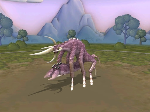
Anyway, enough of that. If you didn't know, the Creature Creator for Spore has been released, and it's an absolute blast to mess around with. The possibilities on what you can create are pretty much endless. Here's a couple that I made:
Last summer I did some experiments with an unusual way of rendering volumetric clouds. The usual way to render volumetric clouds is with a bunch of quads/voxels/slices. But this approach is much simpler, and at least for the exterior, gives really good results.
The problem came when rendering multiple clouds in a field. Due to the way the cloud is rendered, overlapping clouds would produce artifacts, and short of rendering each cloud by itself I couldn't figure out how to eliminate the artifacts. But then again, I didn't spend too much time on them either.
The general approach is as follows:
Draw your scene as usual
Then render a low poly cloud mesh - this could be created in Max/Maya with a group of spheres/ellipsoids in the shape of a cloud
Copy the backbuffer to a render target, and clear the alpha channel
Render the clouds with full alpha and your lighting of choice (I only implemented simple phong shading, a better lighting algorithm would have helped). We'll call this the cloud map.
Blur the cloud map using a Gaussian filter, or another if you like.
After blurring we need to distort the blurred cloud map. To do this, we place a quad at the center of each cloud and billboard each vertex to the camera (make sure the billboard covers the entire cloud from any angle).
Now we render this quad to distort the cloud map. In the pixel shader for the quad we use the projected position as the texture coordinates and shift the texture coordinates based on the angles to the X and Y axis. We then sample a 2-channel fractal/noise texture with these texture coordinates to obtain our distortion offset. Next, we sample the blurred cloud map using the texture coordinates distorted by the distortion offset and the distance from the quad to the camera:
Optionally, after we have distorted our cloud map, we can perform a radial blur for a softer look.
Finally we merge our render target with the back buffer.
A visual representation of the process:
A really simple algorithm that produces a pretty good result. And as you can see, it is essentially a post processing technique. However, it seems that this approach is more suitable to large volcanic or nuclear plumes rather than a dense field of many cumulus clouds (e.g. a large cloud model with many mega particles, as can be seen in the author's images).
My experiment:
Author's images:
There's an article on this technique in Shader X5 and you can find the slides here. If you're thinking of trying this technique out, you really don't need the book. The slides are more than you need to implement it. The only detail is that you don't actually use a fractal cube like the slides say, you really just use a billboarded quad.
Terrain has always been an interest of mine, ever since I loaded my first 8-bit raw heightmap. And last summer I decided to dive into Atmospheric Scattering after reading Ysaneya's developer journal over on gamedev for quite some time.
So I read ATi's paper and looked at their demo and set out to work. Now, I'm not math genious (having only taken calculus and linear algebra), but implementing atmospheric scattering is not for the faint of heart. However, after about a month I had a pretty good working implementation based on the Hoffman and Preetham paper.
Then I started on the water rendering component. There were two articles in Shader X3/4 that were of great help when it came to getting the color just right.
After a couple of months I had a pretty good looking demo. The terrain wasn't anything special, it was just broken down into a quadtree, so I was only able to render 2048x2048 terrain. In order to do this I made the water be at half the height of the terrain and culled the non-visible areas when i was above/below the water, so I was effectively only rendering half of the terrain when I was above/below the water line.
Anyways, on to the pictures: Scene details:
1024x1024 terrain with multi-texturing and aerial perspective
Sky dome with sun and skylight scattering
2048x2048 water plane(size not number of vertices)
Bloom post processing
Written in c# and managed directx
And a video of it in action:
The water has realistic coastal coloring, soft edges when it intersects the terrain, under water fogging, and depth fogging.
This summer I plan to rewrite the whole application in c++. I also want to extend the terrain rendering with geomipmapping, fix the huge sun, and add volumetric clouds. I had tried implementing volumetric clouds using mega particles, but didn't turn out too well in a dense cloud field. Worked really well for volcanic or nuclear plumes though. More on this in a later post.